Lundy and Lisbon
On the west coast of Lundy Island lies a place called Earthquake. Whether there was ever a true earthquake here is a story lost in time. Some accounts suggest the great fissures appeared around 1775 — the same year as the devastating Lisbon earthquake.
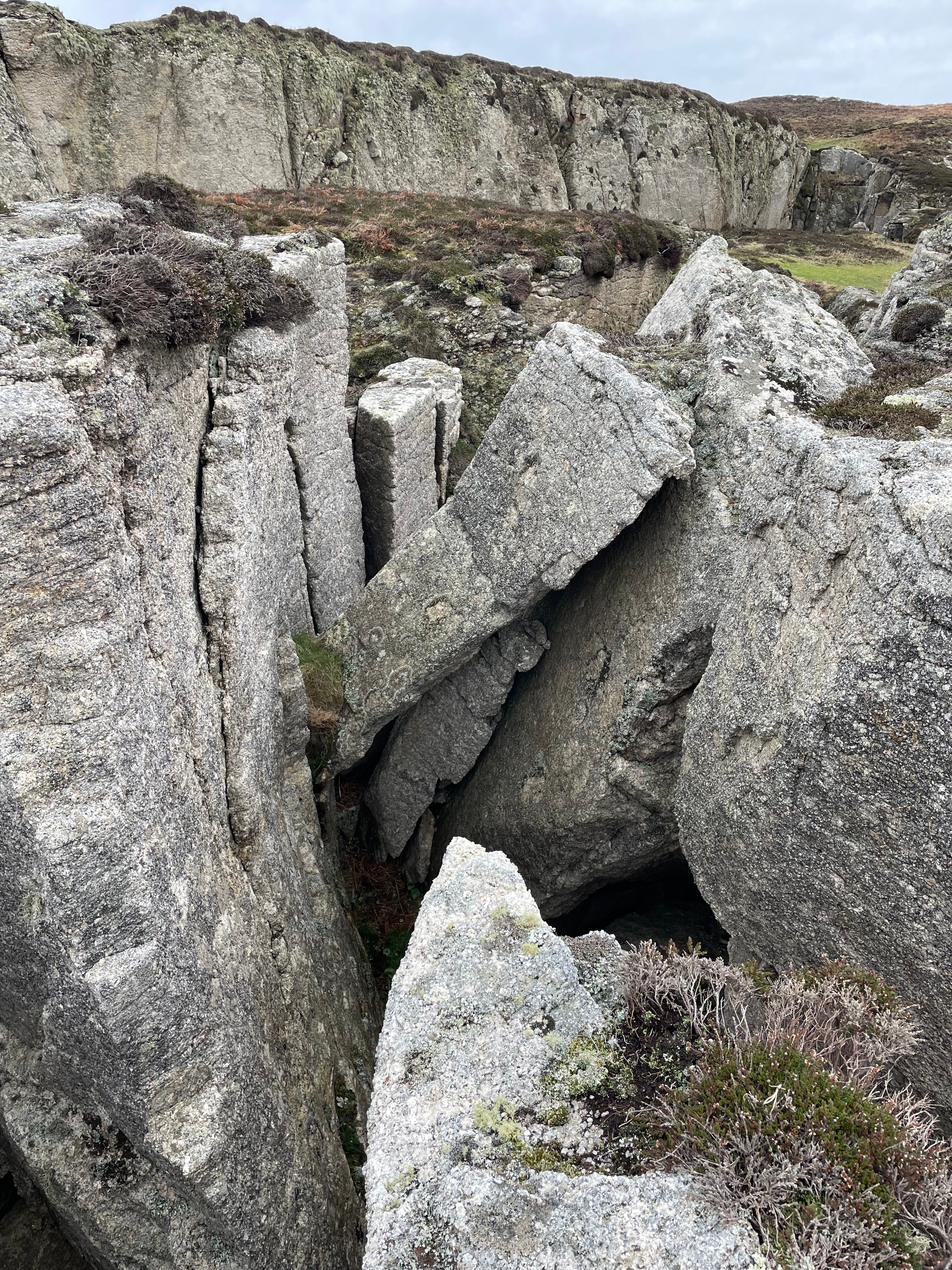
Finding the Lundy Earthquake
To find Earthquake on Lundy Island, you need to head to the West Coast. From the Old Light, walk north, go past the Top of the Battery. Then, cross Quarter Wall and continue beyond Parrot Rock. There are no obvious signs. Navigation here relies on the landscape palimpsest left by past inhabitants. “Layers” of history—old boundaries, ruins, or roads—overwritten by modern life but still visible to the trained eye. Tristan Gooley writes about reading landscapes as guides, and here that skill feels relevant. The land tells you when you are close.
When you reach the Earthquake you can enter a chasm on the right. You will find this is a dead end. For one, it doesn’t go anywhere. You have to turn round to come back. Secondly, you can find dead remains of fallen animals. A dead end in more ways than one !

The path to the Letterbox
To reach the top, you clamber over granite boulders at the entrance. A narrow path runs along the top. This is a well-travelled path for one reason: a hidden Lundy letterbox! Here is one of the 27 Lundy Letterboxes. It is a geocaching game where you follow a set of clues to find hidden boxes. Each box holds a rubber stamp that is unique to its box. The aim is to discover the location of all the boxes. You also need to collect the stamps. The elusive ‘Lundy Bunny’ is a movable stamp. The box here is tiny and hidden amongst the cracks, it flummoxes many a ‘letterboxer’.
I have drawn directions to this letterbox countless times for visitors who have returned frustrated from failed searches. My daughter and I once mapped our own effort using GPS tracking, The amount of times we doubled back. The map tells its own story of confusion and persistence. Walking becomes narrative. Walking also becomes an artwork.

StoryTelling at Earthquake, Lundy
On a guided walk here, we shared stories in the rain. One story was how it reminded the storyteller of Iceland, we immersed ourselves in parliaments and Trolls. We discussed its volcanic landscapes shaped by fissure and fire.

In some ways, Lundy and Iceland share characteristics: igneous origins, dramatic cliffs, seabird colonies, Atlantic weather, isolation. You do not need to travel as far as Iceland to experience elemental landscape. This year, in January the Aurora Borealis was visible from Lundy Island.
Earthquake feels like a natural storytelling chamber. The cracks in the granite invite layers — family stories, imagined futures, half-remembered histories. I recently sat at its north entrance with my brother and sister-in-law. We looked out to the Pyramid and Jenny’s Cove, telling stories.


The deepest cracks here are around 15 metres (50 feet). I have not descended them — only the smaller side chasm near the entrance. Someone once dropped the letterbox stamp into one of the fissures. It is still there. A new stamp had to be made. Imagine searching for hours, finally finding the box, then dropping the prize into the depths.


What stories of Yours surface through the cracks?
Next time you visit Lundy, walk north to Earthquake. Sit for a while. Maybe take a picnic, as stories often surface when food is involved. If you go alone, take a notebook. See what surfaces, write it down and recall that story to another.
- Distance: 3 miles approx.
- Terrain: Boggy on the West Side